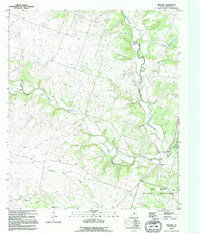
1995 Map of Pidcoke
USGS Topo · Published 1995About this map
Cowhouse Creek and its many tributaries, including Bee House Creek and Perryman Creek, dominate this central Texas landscape in the mid-1990s. The settlement of Pidcoke sits at a strategic crossing point near the eastern edge of the map, marked by the nearby Pidcoke Cemetery and a hydrologic Gaging Station. To the north, the small community of Slater occupies the upland terrain between Patterson Branch and Bee House Creek.
Find a feature on this map
18 named features on this map. Tap any name to fly to it.
Don’t see what you’re looking for? This feature index may not catch every label — zoom into the map to look around manually.
Map Details
Editions of this 1995 Pidcoke Map
This is the sole edition of this map. No revisions or reprints were ever made.
Other maps of this area

1887 · Lampasas
USGS Topo · 1:125,000

1894 · Lampasas
USGS Topo · 1:125,000

1894 · Gatesville
USGS Topo · 1:125,000

1947 · Fort Hood
USGS Topo · 1:62,500

1947 · Fort Hood
USGS Topo · 1:24,000

1947 · Purmela
USGS Topo · 1:62,500

1947 · Gatesville West
USGS Topo · 1:24,000

1947 · Pidcoke
USGS Topo · 1:24,000

1947 · Purmela
USGS Topo · 1:24,000

1947 · Shell Mountains
USGS Topo · 1:24,000