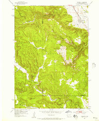
1953 Map of Piedmont
USGS Topo · Published 1957About this map
Piedmont sits at the eastern edge of the Black Hills National Forest, where the transition from high plains to mountainous terrain is defined by the Chicago and North Western rail line. The landscape is deeply incised by a series of dramatic canyons, most notably Stagebarn Canyon and Elk Canyon, which cut through the uplifted limestone and granite. This mid-century survey highlights a region shaped by both natural wonders and early recreation, featuring several subterranean landmarks like Stagebarn Caverns, Erskine Cave, and an Ice Cave. Local landmarks such as Steamboat Rock and the Ski Slide near Dalton Lake reflect the area's development for outdoor use. Educational and community life is anchored by the Pinkerton Sch and Camp Columbus, while the rugged interior remains marked by family-named gulches and peaks like Green Mountain.
Find a feature on this map
35 named features on this map. Tap any name to fly to it.
Don’t see what you’re looking for? This feature index may not catch every label — zoom into the map to look around manually.
Map Details
Editions of this 1953 Piedmont Map
5 editions found
Other maps of this area

1893 · Rapid
USGS Topo · 1:125,000

1894 · Deadwood
USGS Topo · 1:125,000

1898 · Rapid
USGS Topo · 1:125,000

1899 · Sturgis
USGS Topo · 1:62,500

1901 · Deadwood
USGS Topo · 1:125,000

1903 · Rapid
USGS Topo · 1:125,000

1915 · Sturgis
USGS Topo · 1:62,500

1916 · Deadwood
USGS Topo · 1:125,000

1953 · Blackhawk
USGS Topo · 1:24,000

1953 · Piedmont
USGS Topo · 1:24,000