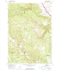
1953 Map of Piedmont
USGS Topo · Published 1972About this map
Piedmont sits at the eastern edge of the Black Hills National Forest, where the prairie meets the rising limestone ridges and deep canyons of South Dakota. In the mid-twentieth century, this landscape was defined by the Chicago and North Western railroad corridor and a network of geological landmarks including Stagebarn Caverns and the Ice Cave. The interior forest reveals a history of early recreation and education, featuring the Dalton Lake Campground and the remote Pinkerton Sch near Boxelder Creek. High points like Steamboat Rock and Green Mountain overlook a complex system of gulches and creeks, such as Erskine Gulch and Bogus Jim Creek, that trace the transition from Lawrence and Meade counties into Pennington County. The presence of Camp Columbus and various named springs underscores the vital importance of reliable water and sheltered locations in this high-elevation terrain.
Find a feature on this map
38 named features on this map. Tap any name to fly to it.
Don’t see what you’re looking for? This feature index may not catch every label — zoom into the map to look around manually.
Map Details
Editions of this 1953 Piedmont Map
5 editions found
Other maps of this area

1893 · Rapid
USGS Topo · 1:125,000

1894 · Deadwood
USGS Topo · 1:125,000

1898 · Rapid
USGS Topo · 1:125,000

1899 · Sturgis
USGS Topo · 1:62,500

1901 · Deadwood
USGS Topo · 1:125,000

1903 · Rapid
USGS Topo · 1:125,000

1915 · Sturgis
USGS Topo · 1:62,500

1916 · Deadwood
USGS Topo · 1:125,000

1953 · Blackhawk
USGS Topo · 1:24,000

1953 · Piedmont
USGS Topo · 1:24,000