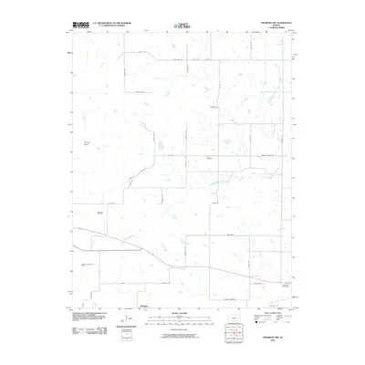
2010 Map of Piedmont NW
USGS Topo · Published 2010About this map
Blodgett sits at the southern edge of this Greenwood County landscape, where the agricultural grid meets the drainage of the North Branch Otter Creek. The map documents a rural transition where traditional ranching and farming operations, represented by landmarks like Wallace Ranch RD, coexist with industrial extraction. The western portion of the quadrangle is defined by the Beaumont Oil Field and the Beaumont South Oil Field, signaling the area's long-standing connection to the petroleum industry. Prominent terrain features like Temple Knob rise above the surrounding plains, providing natural orientation points amidst the network of township roads. Local history is anchored by the Star Cemetery and Piedmont Cemetery, providing vital records for genealogists tracing families in the Otter Creek watershed. The intricate hydrography, including Watson Branch and the South Branch Otter Creek, dictates the winding paths of roads like Love Ln and Sleepy Hollow Rd as they navigate the creek bottoms.
Find a feature on this map
45 named features on this map. Tap any name to fly to it.
Don’t see what you’re looking for? This feature index may not catch every label — zoom into the map to look around manually.
Map Details
Editions of this 2010 Piedmont NW Map
This is the sole edition of this map. No revisions or reprints were ever made.
Other maps of this area

1885 · Eureka
USGS Topo · 1:125,000

1888 · Eureka
USGS Topo · 1:125,000

1888 · Eldorado
USGS Topo · 1:125,000

1894 · Eureka
USGS Topo · 1:125,000

1955 · Wichita
USGS Topo · 1:250,000

1958 · Wichita
USGS Topo · 1:250,000

1961 · Rosalia
USGS Topo · 1:24,000
1964 · Piedmont SW
USGS Topo · 1:24,000

1964 · Piedmont NW
USGS Topo · 1:24,000

1964 · Beaumont
USGS Topo · 1:24,000