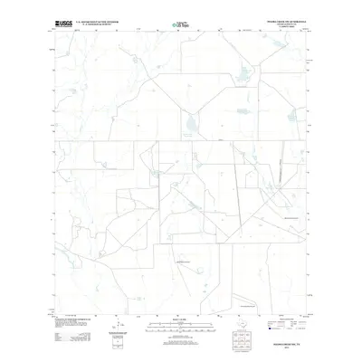
2012 Map of Piedra Creek NW
USGS Topo · Published 2012About this map
The arid ranchlands of La Salle County are defined by a network of seasonal watercourses and private aviation infrastructure in this 2012 survey. Piedra Cr and Sauz Cr snake through the brushy terrain, feeding several named reservoirs and catchment areas such as Welder Lake Number 5 and the Ruhmann Tank. The landscape is largely organized around expansive private holdings, evidenced by the naming of Cameron Ranch Lake-Number 4 and access via Herradura Ranch Rd. This era of the South Texas brush country is also characterized by its reliance on small airstrips, with the El Caballero Airport, Morris Ranch Airport, and the evocatively named Ghost Apache Airport serving the remote properties. Aside from the primary corridor of FM-624, the area remains sparsely developed, focused on cattle ranching and water management at sites like La Mata Lake.
Find a feature on this map
15 named features on this map. Tap any name to fly to it.
Don’t see what you’re looking for? This feature index may not catch every label — zoom into the map to look around manually.
Map Details
Editions of this 2012 Piedra Creek NW Map
This is the sole edition of this map. No revisions or reprints were ever made.
Other maps of this area
1929 · Cotulla
USGS Topo · 1:125,000
1940 · Cotulla
USGS Topo · 1:62,500
1942 · Fowlerton
USGS Topo · 1:62,500

1953 · Crystal City
USGS Topo · 1:250,000

1955 · Crystal City
USGS Topo · 1:250,000
1956 · Piedra Creek
USGS Topo · 1:62,500
1956 · Fowlerton
USGS Topo · 1:62,500
1957 · Caiman Creek
USGS Topo · 1:62,500
1961 · Crystal City
USGS Topo · 1:250,000
1968 · Crystal City
USGS Topo · 1:250,000