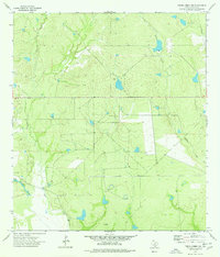
1974 Map of Piedra Creek NW
USGS Topo · Published 1977About this map
Sanz Creek and Piedra Creek define the drainage of this South Texas landscape in the mid-1970s. The area is characterized by low-lying brush country punctuated by man-made alterations for resource extraction and transportation. To the west, La Mata Lake sits near a marked Cem, suggesting early settlement patterns or family ranching roots. Industrial footprints are visible through a Pipeline crossing the northeastern corner and a Gravel Pit in the western reaches. A remote Landing Strip further indicates the isolation of these ranch lands, where aviation often supplemented overland travel. Several marked drill holes and a well underscore the importance of water and mineral exploration in the La Salle County terrain.
Find a feature on this map
9 named features on this map. Tap any name to fly to it.
Don’t see what you’re looking for? This feature index may not catch every label — zoom into the map to look around manually.
Map Details
Editions of this 1974 Piedra Creek NW Map
This is the sole edition of this map. No revisions or reprints were ever made.
Other maps of this area

1929 · Cotulla
USGS Topo · 1:125,000

1940 · Cotulla
USGS Topo · 1:62,500

1942 · Fowlerton
USGS Topo · 1:62,500

1953 · Crystal City
USGS Topo · 1:250,000

1955 · Crystal City
USGS Topo · 1:250,000

1956 · Piedra Creek
USGS Topo · 1:62,500

1956 · Fowlerton
USGS Topo · 1:62,500

1957 · Caiman Creek
USGS Topo · 1:62,500

1961 · Crystal City
USGS Topo · 1:250,000

1968 · Crystal City
USGS Topo · 1:250,000