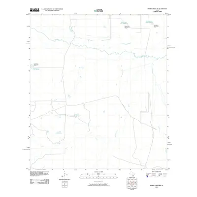
2010 Map of Piedra Creek SW
USGS Topo · Published 2010About this map
The Nueces River winds through this arid section of Webb County, defining a landscape shaped by intermittent water sources and ranching infrastructure. Tributaries like Sauz Creek, San Casimiro Creek, and Black Creek drain toward the river basin, though their flow is seasonal. The ranching heritage of the South Texas brush country is evident in the managed water systems of the Dobie Ranch Tank Number 1, Dobie Ranch Tank Number 2, and Dobie Ranch Tank Number 3, each supported by its own dam. These tanks are critical landmarks in a region where reliable water is scarce. Human presence is light and largely utilitarian, centered on the corridor of Withers Rd, which provides the primary access through these large livestock holdings at the start of the 21st century.
Find a feature on this map
11 named features on this map. Tap any name to fly to it.
Don’t see what you’re looking for? This feature index may not catch every label — zoom into the map to look around manually.
Map Details
Editions of this 2010 Piedra Creek SW Map
This is the sole edition of this map. No revisions or reprints were ever made.
Other maps of this area
1929 · Cotulla
USGS Topo · 1:125,000

1953 · Crystal City
USGS Topo · 1:250,000

1955 · Crystal City
USGS Topo · 1:250,000
1956 · Becerra
USGS Topo · 1:62,500
1956 · Piedra Creek
USGS Topo · 1:62,500
1956 · Las Mujeres
USGS Topo · 1:62,500

1956 · Laredo
USGS Topo · 1:250,000
1957 · Caiman Creek
USGS Topo · 1:62,500
1961 · Crystal City
USGS Topo · 1:250,000
1968 · Crystal City
USGS Topo · 1:250,000