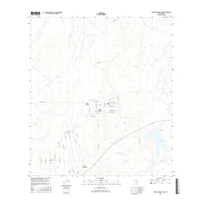
2016 Map of Piedra Parada Tank
USGS Topo · Published 2016About this map
Pueblo East and Valle Verde represent the expanding residential colonias that characterize the landscape of Webb County in the mid-2010s. This survey details a transition from traditional large-scale ranching to organized rural subdivisions, evidenced by the dense network of local roads like Quintana Rd and Reynolds Rd. The arid terrain is defined by a complex drainage system, including the seasonal Piedra Parada Cr and Becerra Cr, which feed into vital water management features such as the Piedra Parada Tank and Vaquillas Reservoir.
Find a feature on this map
45 named features on this map. Tap any name to fly to it.
Don’t see what you’re looking for? This feature index may not catch every label — zoom into the map to look around manually.
Map Details
Editions of this 2016 Piedra Parada Tank Map
This is the sole edition of this map. No revisions or reprints were ever made.
Other maps of this area
1937 · Aguilete Creek
USGS Topo · 1:62,500
1956 · Becerra
USGS Topo · 1:62,500
1956 · Laredo East
USGS Topo · 1:62,500
1956 · Webb
USGS Topo · 1:62,500
1956 · Laredo
USGS Topo · 1:250,000
1965 · Cibolo Ranch
USGS Topo · 1:24,000
1965 · Tios Creek
USGS Topo · 1:24,000
1980 · Alamito Creek
USGS Topo · 1:24,000
1980 · Callaghan Ranch SE
USGS Topo · 1:24,000
1980 · Burrito Tank
USGS Topo · 1:24,000
Featured Places
- Pueblo East Colonia, TX
- East Gate Acres Colonia, TX
- Colorado Acres Colonia, TX
- Ranchitos las Lomas Number 2 Colonia, TX
- Los Veteranos 59 Colonia, TX