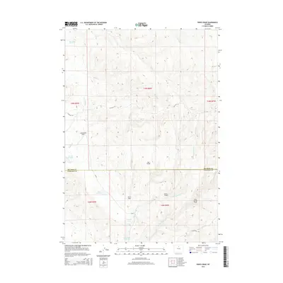
2015 Map of Pierce Draw
USGS Topo · Published 2015About this map
Pierce Draw cuts through the arid landscape of the Wyoming interior, where the border between Big Horn and Washakie counties divides a region defined by its complex drainage network and water management. Irrigation and livestock watering are central to the landscape, evidenced by Renner Reservoir, Deer Draw Reservoir, and Carothers Lake. The terrain is characterized by deep erosional features like Cottonwood Draw and Center Canyon, which serve as conduits for seasonal flows in creeks such as Luman Cr and Military Cr. This 2015 survey shows a rural infrastructure of local routes including Hyattville Rd and N Brokenback Rd, which connect remote ranching interests across the township lines. The name Salt Trough suggests the mineral-rich nature of the local soils, a common trait in this part of the Bighorn Basin where water sources are vital for land utility.
Find a feature on this map
25 named features on this map. Tap any name to fly to it.
Don’t see what you’re looking for? This feature index may not catch every label — zoom into the map to look around manually.
Map Details
Editions of this 2015 Pierce Draw Map
This is the sole edition of this map. No revisions or reprints were ever made.
Other maps of this area
1899 · Cloud peak
USGS Topo · 1:125,000
1901 · Cloud Peak
USGS Topo · 1:125,000

1955 · Sheridan
USGS Topo · 1:250,000

1958 · Sheridan
USGS Topo · 1:250,000
1960 · Lake Solitude
USGS Topo · 1:24,000
1960 · Hyatt Ranch
USGS Topo · 1:24,000

1962 · Sheridan
USGS Topo · 1:250,000
1967 · Old Maid Gulch
USGS Topo · 1:24,000
1967 · Hyattville
USGS Topo · 1:24,000
1967 · Ten Sleep
USGS Topo · 1:24,000