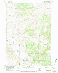
1967 Map of Pierce Draw
USGS Topo · Published 1971About this map
Luman Creek and Laddie Creek carve through the high basins of the Big Horn and Washakie county border during the late 1960s. This survey, based on 1966 aerial photography, reveals a landscape defined by water management and natural drainages. Ranching and livestock infrastructure are evident through numerous named water sources, including the Renner Reservoir and Deer Draw Reservoir. The prevalence of artesian resources is noted by specifically labeled features such as Freddy Well (Flowing) and Renner Well (Flowing). The terrain is further characterized by deep canyons and washes like Pierce Draw and Center Canyon, while a network of trails and jeep trails provides the only evidence of human transit across the Brokenback highlands. The placement of Buffalo Springs and the Flowing Well suggest critical stop-over points in an otherwise arid and sparsely settled territory.
Find a feature on this map
21 named features on this map. Tap any name to fly to it.
Don’t see what you’re looking for? This feature index may not catch every label — zoom into the map to look around manually.
Map Details
Editions of this 1967 Pierce Draw Map
This is the sole edition of this map. No revisions or reprints were ever made.
Other maps of this area

1899 · Cloud peak
USGS Topo · 1:125,000

1901 · Cloud Peak
USGS Topo · 1:125,000

1955 · Sheridan
USGS Topo · 1:250,000

1958 · Sheridan
USGS Topo · 1:250,000

1960 · Lake Solitude
USGS Topo · 1:24,000

1960 · Hyatt Ranch
USGS Topo · 1:24,000

1962 · Sheridan
USGS Topo · 1:250,000
1967 · Old Maid Gulch
USGS Topo · 1:24,000
1967 · Hyattville
USGS Topo · 1:24,000
1967 · Ten Sleep
USGS Topo · 1:24,000