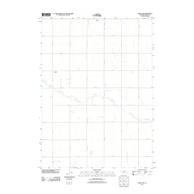
2011 Map of Pierce NW
USGS Topo · Published 2011About this map
Willow Creek meanders through this agricultural landscape in the northwestern reaches of Pierce County, Nebraska. The map detail reflects the long-established section-line grid of the Great Plains, with a systematic network of county roads like 856th Rd and 539th Ave defining the township and range layout. Two small but significant landmarks for local history and genealogy are present: Trinity Cemetery sits at the northern edge of the survey, while Lambrecht Cemetery is located further south along 854 Rd. The lack of dense urbanization highlights the area's ongoing role as a rural farming corridor, where the natural course of the creek provides the only departure from the strict geometry of the surveyed roads.
Find a feature on this map
17 named features on this map. Tap any name to fly to it.
Don’t see what you’re looking for? This feature index may not catch every label — zoom into the map to look around manually.
Map Details
Editions of this 2011 Pierce NW Map
This is the sole edition of this map. No revisions or reprints were ever made.
Other maps of this area

1955 · Sioux City
USGS Topo · 1:250,000

1958 · Sioux City
USGS Topo · 1:250,000

1959 · Sioux City
USGS Topo · 1:250,000

1963 · Pierce NW
USGS Topo · 1:24,000

1963 · Plainview
USGS Topo · 1:24,000

1963 · Pierce SE
USGS Topo · 1:24,000

1963 · Foster
USGS Topo · 1:24,000

1963 · Meadow Grove
USGS Topo · 1:24,000

1963 · Osmond
USGS Topo · 1:24,000
1963 · Tilden NE
USGS Topo · 1:24,000