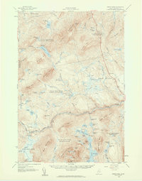
1958 Map of Pierce Pond
USGS Topo · Published 1960About this map
Coburn Mountain and Johnson Mountain dominate this Somerset County landscape, which is defined by a dense network of sporting camps and mountain ponds in the mid-20th century. The Dead River flows through the southern half of the quadrangle, with the Dead River Dam and Hayden Landing marking key points along its course. The map reveals an economy built around seasonal recreation and timber, featuring scattered lodging such as the Comber Inn, Appletree Inn, and numerous camps like Bulldog Camps and Pierce Pond Camps. This era shows a transition in accessibility, with a Jeep Trail threading through the t2 r5 BKP WKR (Lower Enchanted) township. The presence of the Lookout Tower on Coburn Mountain highlights the ongoing importance of fire watch infrastructure during this period of Maine's forest management.
Find a feature on this map
92 named features on this map. Tap any name to fly to it.
Don’t see what you’re looking for? This feature index may not catch every label — zoom into the map to look around manually.
Map Details
Editions of this 1958 Pierce Pond Map
Other maps of this area

1903 · Bingham
USGS Topo · 1:62,500

1905 · Bingham
USGS Topo · 1:62,500

1905 · The Forks
USGS Topo · 1:62,500

1907 · The Forks
USGS Topo · 1:62,500

1921 · Brassua Lake
USGS Topo · 1:62,500

1922 · Long Pond
USGS Topo · 1:62,500

1923 · Brassua Lake
USGS Topo · 1:62,500

1923 · Attean
USGS Topo · 1:62,500

1924 · Long Pond
USGS Topo · 1:62,500

1925 · Pierce Pond
USGS Topo · 1:48,000
Featured Places
- West Forks, ME
- Hayden Landing, Pierce Pond Township
- Upper Enchanted Township, ME
- Johnson Mountain Township, ME
- Bowtown Township, ME