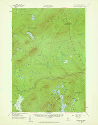
1958 Map of Pierce Pond
USGS Topo · Published 1960About this map
Coburn Mountain dominates the skyline of this Maine wilderness as it appeared in the late 1950s, a landscape defined by organized townships and remote sporting camps. The Dead River carves through the center of the sheet, featuring notable sites like Grand Falls and Spencer Rips, while the settlement of West Forks serves as a small hub along the river's path.
Find a feature on this map
99 named features on this map. Tap any name to fly to it.
Don’t see what you’re looking for? This feature index may not catch every label — zoom into the map to look around manually.
Map Details
Editions of this 1958 Pierce Pond Map
Other maps of this area

1903 · Bingham
USGS Topo · 1:62,500

1905 · Bingham
USGS Topo · 1:62,500

1905 · The Forks
USGS Topo · 1:62,500

1907 · The Forks
USGS Topo · 1:62,500

1921 · Brassua Lake
USGS Topo · 1:62,500

1922 · Long Pond
USGS Topo · 1:62,500

1923 · Brassua Lake
USGS Topo · 1:62,500

1923 · Attean
USGS Topo · 1:62,500

1924 · Long Pond
USGS Topo · 1:62,500

1925 · Pierce Pond
USGS Topo · 1:48,000
Featured Places
- West Forks, ME
- Hayden Landing, Pierce Pond Township
- Upper Enchanted Township, ME
- Johnson Mountain Township, ME
- Bowtown Township, ME