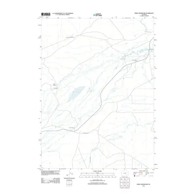
2012 Map of Pierce Reservoir
USGS Topo · Published 2012About this map
Diamond Dome Gas Field defines the northern reaches of this Wyoming landscape, illustrating the intersection of energy extraction and high-plains ranching. The territory is a network of water management systems essential for agricultural survival, featuring an extensive array of irrigation works like the Big Heart Ditch, Whites Rock Creek Ditch, and Bosler Ditch Number 3. These man-made channels support a series of family-named holdings, including Diamond Ranch, Banzhof Ranch, and Double K Ranch, which are situated near the seasonal flows of Threemile Cr and Coalbank Cr. The central basin is dominated by Pierce Reservoir and Little Pierce Reservoir, critical landmarks in an area where water rights and access dictate the layout of roads such as Old State Hwy 13. The map offers a precise view of early 21st-century land use, where natural drainages like Frank Draw are heavily modified by historic water claims.
Find a feature on this map
21 named features on this map. Tap any name to fly to it.
Don’t see what you’re looking for? This feature index may not catch every label — zoom into the map to look around manually.
Map Details
Editions of this 2012 Pierce Reservoir Map
This is the sole edition of this map. No revisions or reprints were ever made.
Other maps of this area

1915 · Como Ridge
USGS Topo · 1:48,000

1918 · Como Ridge
USGS Topo · 1:62,500

1954 · Cheyenne
USGS Topo · 1:250,000

1954 · Rawlins
USGS Topo · 1:250,000

1955 · Big Judson
USGS Topo · 1:24,000

1955 · Rock River
USGS Topo · 1:24,000

1955 · Wilcox
USGS Topo · 1:24,000

1958 · Rawlins
USGS Topo · 1:250,000

1958 · Cheyenne
USGS Topo · 1:250,000

1958 · Bengough Hill
USGS Topo · 1:24,000