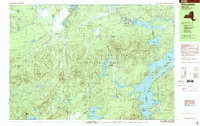
1999 Map of Piercefield
USGS Topo · Published 2001About this map
Adirondack Park dominates this late-twentieth-century landscape, where the waters of the Raquette River and Piercefield Flow meet the settlement of Piercefield. The area is defined by its complex hydrology and high peaks, including Arab Mountain and Buck Mountain. Small outposts such as Conifer and Childwold Station suggest the region's history of rail-and-timber industry, while landmarks like the Mt Arab Station indicate a geography shaped by both transit and wilderness protection. To the southeast, the expanse of Tupper Lake is dotted with features like Norway Island and Green Island, marking the transition into the deeper woods and waters of the central Adirondacks. The map also captures the St Lawrence and Franklin County boundary as it cuts through the lake and surrounding forest, providing a precise record of late 1990s land use and natural boundaries.
Find a feature on this map
82 named features on this map. Tap any name to fly to it.
Don’t see what you’re looking for? This feature index may not catch every label — zoom into the map to look around manually.
Map Details
Editions of this 1999 Piercefield Map
This is the sole edition of this map. No revisions or reprints were ever made.
Other maps of this area

1904 · Long Lake
USGS Topo · 1:62,500

1905 · Saint Regis
USGS Topo · 1:62,500

1907 · Tupper Lake
USGS Topo · 1:62,500

1919 · Cranberry Lake
USGS Topo · 1:62,500

1920 · Childwold
USGS Topo · 1:62,500

1921 · Cranberry Lake
USGS Topo · 1:62,500

1921 · Childwold
USGS Topo · 1:48,000

1921 · Stark
USGS Topo · 1:62,500

1922 · Childwold
USGS Topo · 1:62,500

1923 · Stark
USGS Topo · 1:62,500