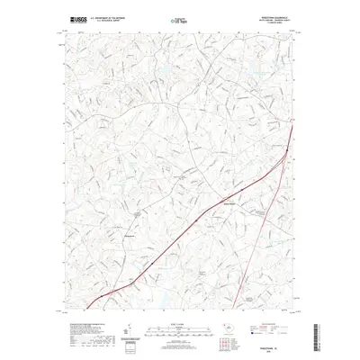
2020 Map of Piercetown
USGS Topo · Published 2020About this map
Piercetown and White Plains anchor this South Carolina landscape, where the upper Piedmont’s agricultural and residential character is defined by a dense network of creek drainages. Significant genealogical sites are distributed across the terrain, including the Friendship Baptist Church Graveyard and Beaverdam Baptist Church Cem, alongside family-named locations such as Pickens Cem. The region is dissected by numerous waterways, most notably Six and Twenty Cr and Beaverdam Cr, which have been modified over time by infrastructure like the Brushy Cr Watershed 18 Reservoir. Modern development is evident in the residential road patterns surrounding Pine Crest Lake and Stoneybrook Lake, yet the map still reflects a traditional rural layout centered on longstanding community intersections and church-centered settlements. This 2020 survey captures the area’s evolution into a sprawling suburban-rural mix while preserving the names of the early homesteads and congregations that first established these crossroads.
Find a feature on this map
203 named features on this map. Tap any name to fly to it.
Don’t see what you’re looking for? This feature index may not catch every label — zoom into the map to look around manually.
Map Details
Editions of this 2020 Piercetown Map
This is the sole edition of this map. No revisions or reprints were ever made.
Other maps of this area

1888 · Pickens
USGS Topo · 1:125,000

1894 · Pickens
USGS Topo · 1:125,000

1935 · Greenville
USGS Topo · 1:48,000

1938 · Greenville
USGS Topo · 1:62,500

1954 · Greenville
USGS Topo · 1:250,000

1957 · Greenville
USGS Topo · 1:24,000

1957 · Anderson
USGS Topo · 1:62,500

1957 · Easley
USGS Topo · 1:62,500

1957 · Williamston
USGS Topo · 1:62,500

1957 · Greenville
USGS Topo · 1:62,500