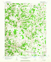
1961 Map of Pierceville
USGS Topo · Published 1963About this map
Pierceville and the surrounding townships of Laughery and Delaware define this rural landscape during the early 1960s. The region is characterized by a dense network of country roads connecting established community centers like Milan and Old Milan. Transportation history is prominent here, with the Baltimore and Ohio railroad cutting a path through the southern townships, while the former Ohio and Mississippi RR route, marked here as Old Milan Rd, traces the area's older transit corridors.
Find a feature on this map
31 named features on this map. Tap any name to fly to it.
Don’t see what you’re looking for? This feature index may not catch every label — zoom into the map to look around manually.
Map Details
Editions of this 1961 Pierceville Map
Other maps of this area

1946 · Versailles
USGS Topo · 1:24,000

1946 · Milan
USGS Topo · 1:24,000

1946 · Pierceville
USGS Topo · 1:24,000

1946 · Batesville
USGS Topo · 1:24,000

1946 · Osgood
USGS Topo · 1:24,000

1946 · New Point
USGS Topo · 1:24,000

1953 · Cincinnati
USGS Topo · 1:250,000

1957 · Cincinnati
USGS Topo · 1:250,000

1958 · Spades
USGS Topo · 1:24,000

1958 · Sunman
USGS Topo · 1:24,000