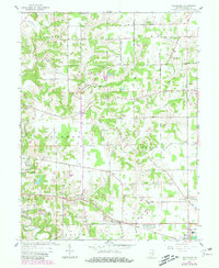
1961 Map of Pierceville
USGS Topo · Published 1981About this map
Laughery Creek winds through the rolling landscape of eastern Ripley County, defining the rural character of this region during the mid-20th century. The settlement pattern is anchored by small community nodes such as Pierceville, Delaware, and Old Milan, each connected by a network of local roads that bridge numerous waterways, including the notable Covered Bridge and Laughery Bridge. The area maintains a strong pastoral identity, evidenced by the distribution of country churches and family-linked burial grounds like Little Memory Ch and the Adams Cem.
Find a feature on this map
36 named features on this map. Tap any name to fly to it.
Don’t see what you’re looking for? This feature index may not catch every label — zoom into the map to look around manually.
Map Details
Editions of this 1961 Pierceville Map
Other maps of this area

1946 · Versailles
USGS Topo · 1:24,000

1946 · Milan
USGS Topo · 1:24,000

1946 · Pierceville
USGS Topo · 1:24,000

1946 · Batesville
USGS Topo · 1:24,000

1946 · Osgood
USGS Topo · 1:24,000

1946 · New Point
USGS Topo · 1:24,000

1953 · Cincinnati
USGS Topo · 1:250,000

1957 · Cincinnati
USGS Topo · 1:250,000

1958 · Spades
USGS Topo · 1:24,000

1958 · Sunman
USGS Topo · 1:24,000