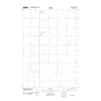
2012 Map of Pierpont
USGS Topo · Published 2012About this map
The town of Pierpont occupies the northern reaches of this survey, organized around a traditional grid that includes Railway Ave, 4th St, and 1st St. This South Dakota landscape is defined by its meticulous section-line road network, where routes like 420th Ave and 133rd St facilitate access across the prairie. The most prominent geographic feature is Pierpont Lake, a significant water body situated south of the main settlement. The map reveals a highly structured agricultural environment, with the regular spacing of avenues such as 418th Ave and 423rd Ave reflecting the systematic land division of the region. This 2012 documentation serves as a clear record of the intersection between rural town planning and the surrounding natural hydrology.
Find a feature on this map
17 named features on this map. Tap any name to fly to it.
Don’t see what you’re looking for? This feature index may not catch every label — zoom into the map to look around manually.
Map Details
Editions of this 2012 Pierpont Map
This is the sole edition of this map. No revisions or reprints were ever made.
Other maps of this area

1953 · Milbank
USGS Topo · 1:250,000

1958 · Milbank
USGS Topo · 1:250,000

1958 · Britton 4 SW
USGS Topo · 1:24,000

1958 · Andover
USGS Topo · 1:24,000

1958 · Andover SW
USGS Topo · 1:24,000

1958 · Langford
USGS Topo · 1:24,000

1958 · Pierpont
USGS Topo · 1:24,000
1958 · Langford SW
USGS Topo · 1:24,000

1973 · Lynn Lake
USGS Topo · 1:24,000

1973 · Bristol West
USGS Topo · 1:24,000