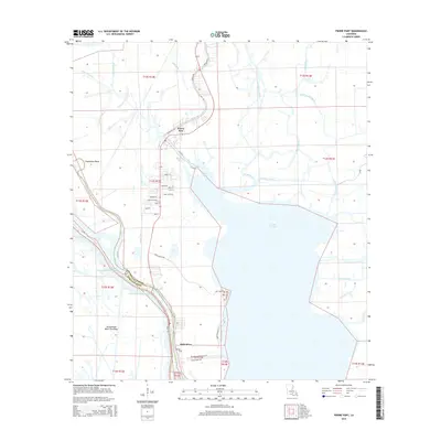
2015 Map of Pierre Part
USGS Topo · Published 2015About this map
Pierre Part serves as the focal point of this low-lying landscape where the bayou culture of South Louisiana meets the edge of the Atchafalaya Basin Floodway. Situated along the banks of Bayou Pierre Part and Pierre Bay, the settlement transitions into a dense network of waterways including Bayou Natchez and Bayou Grosbec. The presence of Lake Verret dominates the eastern half of the map, while the Gulf Intracoastal Waterway cuts through the southwest, underscoring the region's importance to maritime transit. The geography here is defined by linear residential patterns that follow the natural levees, particularly visible at Belle River and Population Bend. Navigating these marshes relies on a complex system of local bayous like Grand Bayou and man-made features such as the Talbot Canal, illustrating the enduring relationship between the community and the surrounding wetlands.
Find a feature on this map
48 named features on this map. Tap any name to fly to it.
Don’t see what you’re looking for? This feature index may not catch every label — zoom into the map to look around manually.
Map Details
Editions of this 2015 Pierre Part Map
This is the sole edition of this map. No revisions or reprints were ever made.
Other maps of this area

1935 · Chicot Lake
USGS Topo · 1:62,500

1936 · White Castle
USGS Topo · 1:62,500

1945 · New Orleans
USGS Topo · 1:250,000

1948 · Foster
USGS Topo · 1:62,500

1953 · Napoleonville
USGS Topo · 1:62,500

1954 · Chicot Lake
USGS Topo · 1:62,500

1954 · Baton Rouge
USGS Topo · 1:250,000
1955 · Chicot Lake
USGS Topo · 1:62,500

1956 · Baton Rouge
USGS Topo · 1:250,000

1959 · Foster
USGS Topo · 1:62,500