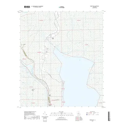
2018 Map of Pierre Part
USGS Topo · Published 2018About this map
Pierre Part serves as the focal point of this coastal Louisiana landscape, where the labyrinthine waterways of the Atchafalaya Basin meet the northern reaches of Lake Verret. The settlement pattern follows the natural levees of the bayous, with long-established communities like Population Bend and Belle River tightly bound to the riparian corridors. This 2018 survey reveals a modern transportation network of local streets, such as Shell Beach Rd and Leonie St, integrated into a terrain dominated by hydrologic features like Grand Bayou and Bayou Alcide. To the west, the Atchafalaya Basin Floodway and the Intracoastal Waterway signify the managed nature of this environment, where dredging and flood control infrastructure coexist with traditional fishing and trapping grounds. The map provides a detailed look at the transition from open water bodies like Bay Natchez to the intricate network of canals and bayous that define life in St. Martin and Assumption parishes.
Find a feature on this map
45 named features on this map. Tap any name to fly to it.
Don’t see what you’re looking for? This feature index may not catch every label — zoom into the map to look around manually.
Map Details
Editions of this 2018 Pierre Part Map
This is the sole edition of this map. No revisions or reprints were ever made.
Other maps of this area

1935 · Chicot Lake
USGS Topo · 1:62,500

1936 · White Castle
USGS Topo · 1:62,500

1945 · New Orleans
USGS Topo · 1:250,000

1948 · Foster
USGS Topo · 1:62,500

1953 · Napoleonville
USGS Topo · 1:62,500

1954 · Chicot Lake
USGS Topo · 1:62,500

1954 · Baton Rouge
USGS Topo · 1:250,000
1955 · Chicot Lake
USGS Topo · 1:62,500

1956 · Baton Rouge
USGS Topo · 1:250,000

1959 · Foster
USGS Topo · 1:62,500