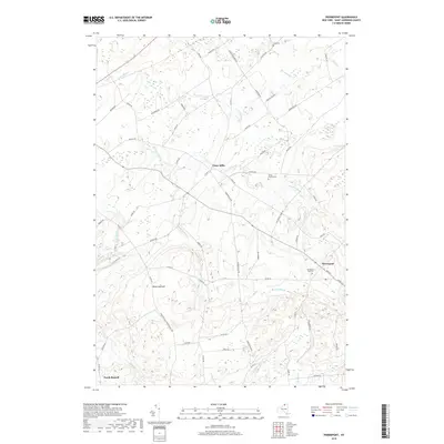
2019 Map of Pierrepont
USGS Topo · Published 2019About this map
Pierrepont and Crary Mills anchor this portion of Saint Lawrence County, where a dense network of country roads connects scattered hamlets and family-named cemeteries. The terrain is defined by a complex hydrography of small waterways, including Grannis Brook, Little River, and Boyden Brook, which drain the undulating landscape toward the north and west. For those tracking local family history, several dedicated burial grounds are marked, such as the Pierrepont Hill Cem and the White Church Cem near the center of the sheet. Rising above the surrounding valleys, Waterman Hill provides a distinct topographic landmark in the southwestern quadrant. The settlement at North Russell further illustrates the rural character of the region, where historical property lines and roads like Butternut Ridge Rd and Howardville Rd suggest a landscape long-shaped by small-scale agriculture and timber.
Find a feature on this map
65 named features on this map. Tap any name to fly to it.
Don’t see what you’re looking for? This feature index may not catch every label — zoom into the map to look around manually.
Map Details
Editions of this 2019 Pierrepont Map
This is the sole edition of this map. No revisions or reprints were ever made.
Other maps of this area

1908 · Potsdam
USGS Topo · 1:62,500

1910 · Canton
USGS Topo · 1:62,500

1911 · Canton
USGS Topo · 1:62,500

1915 · Russell
USGS Topo · 1:62,500

1918 · Russell
USGS Topo · 1:62,500

1921 · Stark
USGS Topo · 1:62,500

1923 · Stark
USGS Topo · 1:62,500

1940 · Stark
USGS Topo · 1:62,500

1943 · Potsdam
USGS Topo · 1:31,680
1943 · Colton
USGS Topo · 1:31,680