
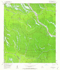
1953 Map of Pigeon Bay
USGS Topo · Published 1954About this map
The Atchafalaya Floodway dominates this mid-century landscape at the border of Iberville and St. Martin parishes. This area is a complex web of wetlands and waterways, defined by the East Protection Levee which serves as a hard boundary between the wilder basin and the narrow strip of development along the Grand River. Near the levee, the Grand River Sch and a Gaging Station mark the local community's adaptation to this aqueous environment. The map records a dense network of hydrologic features including the wide Pigeon Bay and curiously named channels like Graveyard Bayou and Bloody Bayou. Inland industry is represented by the Superior Canal and various pipelines, while the myriad bayous—from Bayou Maringouin to Sorrel Bayou—illustrate the natural drainage patterns of the Louisiana swamp before extensive modern alteration.
Find a feature on this map
47 named features on this map. Tap any name to fly to it.
Don’t see what you’re looking for? This feature index may not catch every label — zoom into the map to look around manually.
Map Details
Editions of this 1953 Pigeon Bay Map
2 editions found
Other maps of this area

1935 · Osca Bayou
USGS Topo · 1:62,500

1935 · Chicot Lake
USGS Topo · 1:62,500

1940 · Grosse Tete
USGS Topo · 1:62,500

1941 · Loreauville
USGS Topo · 1:62,500

1953 · Crescent
USGS Topo · 1:24,000

1953 · Cow Bayou
USGS Topo · 1:24,000

1953 · Addis
USGS Topo · 1:24,000

1953 · Grosse Tete SW
USGS Topo · 1:24,000

1954 · Chicot Lake
USGS Topo · 1:62,500

1954 · Loreauville
USGS Topo · 1:62,500