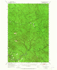
1953 Map of Pigeon Springs
USGS Topo · Published 1965About this map
Pigeon Springs sits at the southern edge of this mid-century topographic survey, where the Kalama River snakes through the high timberlands of Cowlitz County. The landscape is defined by the three major drainage systems of the South Fork Toutle River, the Coweman River, and the Kalama, each separated by prominent ridges such as Baird Mountain and Nineteen Mtn. The presence of the Coweman Ranger Sta and Camp Coweman indicates the area's importance for forest management and resource oversight during the early 1950s.
Find a feature on this map
38 named features on this map. Tap any name to fly to it.
Don’t see what you’re looking for? This feature index may not catch every label — zoom into the map to look around manually.
Map Details
Editions of this 1953 Pigeon Springs Map
3 editions found

Other maps of this area

1919 · Mount St Helens
USGS Topo · 1:125,000

1921 · Kalama
USGS Topo · 1:62,500

1922 · St. Helens
USGS Topo · 1:62,500

1940 · La Center
USGS Topo · 1:62,500

1941 · Yacolt
USGS Topo · 1:62,500

1941 · St Helens
USGS Topo · 1:62,500

1941 · Olequa
USGS Topo · 1:62,500

1942 · Toutle
USGS Topo · 1:62,500

1943 · Pigeon Springs
USGS Topo · 1:62,500

1943 · St Helens
USGS Topo · 1:62,500