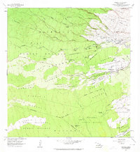
1963 Map of Piihonua
USGS Topo · Published 1964About this map
Wailuku River carves through a landscape defined by volcanic history and early 20th-century settlement patterns in this survey of the South Hilo District. The map provides a detailed record of the terrestrial scars left by the Lava Flow of 1855, the Lava Flow of 1881, and the Lava Flow of 1852, showing how these events shaped the development of Punahoa Homesteads and Kaumana Homesteads.
Find a feature on this map
74 named features on this map. Tap any name to fly to it.
Don’t see what you’re looking for? This feature index may not catch every label — zoom into the map to look around manually.
Map Details
Editions of this 1963 Piihonua Map
This is the sole edition of this map. No revisions or reprints were ever made.
Other maps of this area

1915 · Honomu
USGS Topo · 1:62,500

1917 · Hilo
USGS Topo · 1:62,500

1930 · Humuula
USGS Topo · 1:62,500

1932 · Hilo
USGS Topo · 1:62,500

1954 · Hawaii North
USGS Topo · 1:250,000

1956 · Pua Akala
USGS Topo · 1:24,000

1956 · Upper Piihonua
USGS Topo · 1:24,000
1956 · Kulani
USGS Topo · 1:24,000

1959 · Hawaii North
USGS Topo · 1:250,000

1961 · Hawaii North
USGS Topo · 1:250,000