
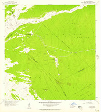
1977 Map of Piihonua
USGS Topo · Published 1981About this map
Piihonua and Kaumana represent the primary centers of human activity on this orthophotograph, where the dense tropical vegetation of the Big Island meets residential expansion. The imagery, captured by the U.S. Geological Survey in late 1976 and early 1977, provides a stark visual contrast between the manicured street grids and the surrounding forest. The Waiau Stream cuts through the northern landscape, its path partially obscured by the thick canopy. For those studying the growth of Hilo’s outskirts, this map reveals the specific footprint of suburban development as it pushed into the highlands. The clear distinction between the cleared lands and the deep shadows of the forest provides a precise record of the land use patterns and topographical challenges encountered during the mid-to-late 1970s.
Find a feature on this map
3 named features on this map. Tap any name to fly to it.
Don’t see what you’re looking for? This feature index may not catch every label — zoom into the map to look around manually.
Map Details
Editions of this 1977 Piihonua Map
This is the sole edition of this map. No revisions or reprints were ever made.
Other maps of this area

1915 · Honomu
USGS Topo · 1:62,500

1917 · Hilo
USGS Topo · 1:62,500

1930 · Humuula
USGS Topo · 1:62,500

1932 · Hilo
USGS Topo · 1:62,500

1954 · Hawaii North
USGS Topo · 1:250,000

1956 · Pua Akala
USGS Topo · 1:24,000

1956 · Upper Piihonua
USGS Topo · 1:24,000
1956 · Kulani
USGS Topo · 1:24,000

1959 · Hawaii North
USGS Topo · 1:250,000

1961 · Hawaii North
USGS Topo · 1:250,000