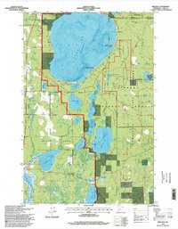
1996 Map of Pike Bay
USGS Topo · Published 1998About this map
Pike Bay and the southern reaches of Cass Lake dominate this portion of north-central Minnesota, where complex glacial hydrology creates a landscape of interconnected basins and wetlands. The map documents a heavily managed timber and recreational environment within the Chippewa National Forest, featuring specialized infrastructure such as the Ojibway Impoundment and the Experimental Forest Impoundment. Settlement patterns are concentrated near the northern shoreline, marked by the Cass Lake Church and the Thompson Cemetery, while the interior is accessible via a network of forest roads and conservation-focused paths like the Norway Beach Interpretive Trail. Long-standing industrial footprints are visible through the Soo Line rail corridor and several Gravel Pits, illustrating the historical intersection of transportation and resource extraction in the region. The map also delineates the boundaries of the Bowstring State Forest and Welsh Lake State Forest, emphasizing the area's role as a protected wilderness managed for multiple uses.
Find a feature on this map
31 named features on this map. Tap any name to fly to it.
Don’t see what you’re looking for? This feature index may not catch every label — zoom into the map to look around manually.
Map Details
Editions of this 1996 Pike Bay Map
This is the sole edition of this map. No revisions or reprints were ever made.
Other maps of this area

1954 · Bemidji
USGS Topo · 1:250,000

1957 · Bemidji
USGS Topo · 1:250,000

1958 · Bemidji
USGS Topo · 1:250,000

1971 · Sucker Lakes
USGS Topo · 1:24,000

1971 · Pennington
USGS Topo · 1:24,000
1971 · Ottertail Point
USGS Topo · 1:24,000

1972 · Steamboat Bay
USGS Topo · 1:24,000

1972 · Benedict
USGS Topo · 1:24,000

1972 · Pike Bay
USGS Topo · 1:24,000
1972 · Cass Lake
USGS Topo · 1:24,000