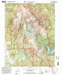
1994 Map of Pikes Peak
USGS Topo · Published 2001About this map
Pikes Peak dominates this 1990s landscape, serving as the high point for a complex network of high-altitude water management and early mining endeavors. The Summit House and Pikes Peak Auto Toll Road highlight the summit's long-standing role as a destination, while the surrounding Pike National Forest contains critical infrastructure including Bison Reservoir, Mason Reservoir, and the Oil Creek Tunnel. Near the southwest corner, the settlement of Gillett appears alongside various prospects and ruins, reflecting the area's legacy of resource extraction. This era shows a landscape transitioned from raw frontier to a managed forest and municipal watershed, where remote outposts like Barr Camp and features like Seven Lakes remain key landmarks for those navigating the high country between Cow Mountain and the steep drops of the Bottomless Pit.
Find a feature on this map
43 named features on this map. Tap any name to fly to it.
Don’t see what you’re looking for? This feature index may not catch every label — zoom into the map to look around manually.
Map Details
Editions of this 1994 Pikes Peak Map
This is the sole edition of this map. No revisions or reprints were ever made.
Other maps of this area

1893 · Colorado Springs
USGS Topo · 1:125,000

1894 · Pikes Peak
USGS Topo · 1:125,000

1901 · Pikes Peak
USGS Topo · 1:125,000

1901 · Pikes Peak
USGS Topo · 1:62,500

1909 · Colorado Springs
USGS Topo · 1:125,000

1942 · Colorado Springs
USGS Topo · 1:125,000

1948 · Mount Big Chief
USGS Topo · 1:24,000

1948 · Manitou Springs
USGS Topo · 1:24,000

1948 · Colorado Springs
USGS Topo · 1:62,500

1948 · Cascade
USGS Topo · 1:24,000