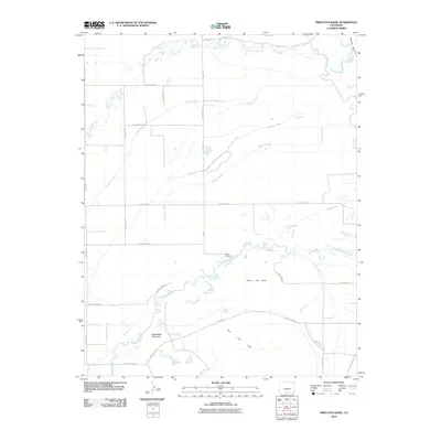
2010 Map of Pikes Stockade
USGS Topo · Published 2010About this map
Pikes Stockade stands at a historic confluence in Alamosa County, marking a landscape defined by complex water management and high-desert terrain. In this 2010 survey, the Conejos River and Rio Grande dominate the hydrology of the valley, supported by an intricate network of irrigation features including the Stewart Ditch, Lasauses Lateral, and Tenfoot Lateral. These engineered waterways suggest a long-standing reliance on diverted surface water for local agriculture between the San Luis Hills and Hansen Bluff. Natural water sources like McIntire Spring and Dexter Springs appear alongside prominent geological landmarks such as Saddleback Mountain and Sierro del Ojito. The map illustrates how human settlement and infrastructure, evidenced by the grid of county roads, have adapted to the winding paths of La Jara Creek and the seasonal demands of the San Luis Valley.
Find a feature on this map
37 named features on this map. Tap any name to fly to it.
Don’t see what you’re looking for? This feature index may not catch every label — zoom into the map to look around manually.
Map Details
Editions of this 2010 Pikes Stockade Map
This is the sole edition of this map. No revisions or reprints were ever made.
Other maps of this area

1954 · Trinidad
USGS Topo · 1:250,000

1955 · Trinidad
USGS Topo · 1:250,000

1958 · Trinidad
USGS Topo · 1:250,000

1959 · Trinidad
USGS Topo · 1:250,000

1965 · Baldy
USGS Topo · 1:24,000

1965 · Lasauses
USGS Topo · 1:24,000
1966 · Alamosa East
USGS Topo · 1:24,000
1966 · Alamosa West
USGS Topo · 1:24,000

1967 · Manassa NE
USGS Topo · 1:24,000
1967 · Manassa
USGS Topo · 1:24,000