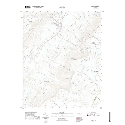
2019 Map of Pikeville
USGS Topo · Published 2019About this map
Pikeville serves as the central hub of this topographical study, positioned where the Sequatchie Valley meets the dramatic rise of the Cumberland Escarpment. The settlement patterns here follow the valley floor, with small communities like Lees Station and West End situated along the drainage of the Sequatchie River. Genealogy researchers will find numerous family-named landmarks and resting places, including McReynolds Cem, Henson Cem, and Vernon Cem. To the west, the landscape is defined by the Cumberland Plateau, featuring the uniquely named The Penitentiary and Penitentiary Gulf. On the eastern side of the quadrangle, the terrain transitions to Walden Ridge, where the community of New Harmony sits atop the high ground. The map details a network of rural roads such as the Alvin C York Hwy and State Hwy 443, which navigate the gaps and coves of the ridge, including Rigsby Gap and Loyd Cove.
Find a feature on this map
107 named features on this map. Tap any name to fly to it.
Don’t see what you’re looking for? This feature index may not catch every label — zoom into the map to look around manually.
Map Details
Editions of this 2019 Pikeville Map
This is the sole edition of this map. No revisions or reprints were ever made.
Other maps of this area

1888 · Chattanooga
USGS Topo · 1:125,000

1892 · Pikeville
USGS Topo · 1:125,000

1893 · Chattanooga
USGS Topo · 1:125,000

1895 · Pikeville
USGS Topo · 1:125,000

1909 · Sequatchie Valley
USGS Topo · 1:62,500

1910 · Pikeville
USGS Topo · 1:62,500

1935 · Melvine
USGS Topo · 1:24,000

1935 · Morgan Springs
USGS Topo · 1:24,000

1935 · Brockdell
USGS Topo · 1:24,000

1935 · Billingsley Gap
USGS Topo · 1:24,000