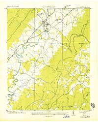
1935 Map of Pikeville
USGS Topo · Published 1935About this map
The Sequatchie Valley floor is anchored by Pikeville in this 1935 field examination, which illustrates the area's rural infrastructure during a transformative decade for Tennessee. The map details a landscape defined by the Cumberland Plateau and the meandering Sequatchie River, where family-named crossings like Hembree Ford provided essential transit. Significant New Deal era activity is present with CCC Camp Sam Houston No 1466 located northeast of the town center. Genealogists will find a wealth of local landmarks, including several rural congregations and burial grounds such as Mt Zion Ch, Vernon Cem, and the Shoemate Cem. Transport and industry are represented by the Nashville Chattanooga and St Louis Railway and early regional infrastructure like the Tennessee Electric Power Company Transmission Line and Alvin C York U S Highway No 28.
Find a feature on this map
48 named features on this map. Tap any name to fly to it.
Don’t see what you’re looking for? This feature index may not catch every label — zoom into the map to look around manually.
Map Details
Editions of this 1935 Pikeville Map
This is the sole edition of this map. No revisions or reprints were ever made.
Other maps of this area

1888 · Chattanooga
USGS Topo · 1:125,000

1892 · Pikeville
USGS Topo · 1:125,000

1893 · Chattanooga
USGS Topo · 1:125,000

1895 · Pikeville
USGS Topo · 1:125,000

1909 · Sequatchie Valley
USGS Topo · 1:62,500

1910 · Pikeville
USGS Topo · 1:62,500

1935 · Melvine
USGS Topo · 1:24,000

1935 · Morgan Springs
USGS Topo · 1:24,000

1935 · Brockdell
USGS Topo · 1:24,000

1935 · Billingsley Gap
USGS Topo · 1:24,000