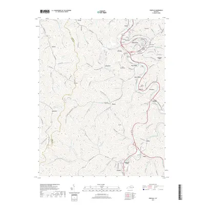
2019 Map of Pikeville
USGS Topo · Published 2019About this map
Pikeville sits at the heart of this Appalachian landscape, where the town spans the Levisa Fork and its surrounding valley floor. The geography is defined by a dense network of hollows and ridges, including Cider Poor Farm Ridge and Peach Orchard Mtn, which separate the various residential and industrial clusters. Small settlements like Mayo Village, Yorktown, and Kewanee line the primary transit corridors, while more isolated locales such as Pigeon and Little Dixie are tucked into the branching creek drainages. Genealogists will find a significant number of family burial sites throughout the area, including Dill Cem, the John Mimms Sword-Cem, and Potter Cem. The map illustrates the contemporary infrastructure of the region, featuring several river crossings like the Lower Bridge and Upper Bridge, alongside landmarks such as Titan Siding and Narrows Bottom.
Find a feature on this map
142 named features on this map. Tap any name to fly to it.
Don’t see what you’re looking for? This feature index may not catch every label — zoom into the map to look around manually.
Map Details
Editions of this 2019 Pikeville Map
This is the sole edition of this map. No revisions or reprints were ever made.
Other maps of this area

1886 · Prestonsburg
USGS Topo · 1:125,000

1886 · Grundy
USGS Topo · 1:125,000

1887 · Warfield
USGS Topo · 1:125,000

1890 · Whitesburg
USGS Topo · 1:125,000

1890 · Grundy
USGS Topo · 1:125,000

1891 · Warfield
USGS Topo · 1:125,000

1892 · Grundy
USGS Topo · 1:125,000

1892 · Whitesburg
USGS Topo · 1:125,000

1892 · Prestonsburg
USGS Topo · 1:125,000

1914 · Laynesville
USGS Topo · 1:48,000