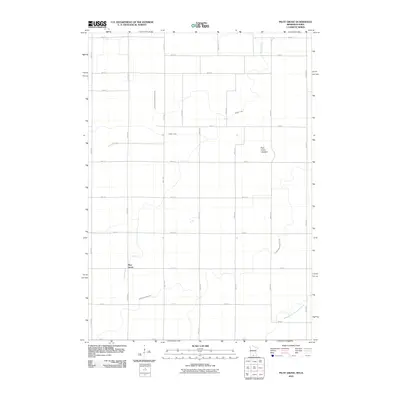
2010 Map of Pilot Grove
USGS Topo · Published 2010About this map
Pilot Grove anchors this rural landscape in Faribault County, situated within a strictly organized grid of agricultural roads like 320th Ave and 30th St. The terrain is defined by its sophisticated drainage network, featuring Judicial Ditch Number Nineteen and Judicial Ditch Number Seven, which transformed the prairie into productive farmland. A prominent geological feature, the Pilot Grove Lakebed, sits centrally, illustrating the area's post-glacial transition from wetland to tillable earth. Along the southern edge, the West Branch Blue Earth River meanders through the township, providing a natural contrast to the engineered channels of Badger Creek. This map offers a clear look at the intersection of natural hydrology and the persistent human effort to manage the water table for Midwestern agriculture.
Find a feature on this map
33 named features on this map. Tap any name to fly to it.
Don’t see what you’re looking for? This feature index may not catch every label — zoom into the map to look around manually.
Map Details
Editions of this 2010 Pilot Grove Map
This is the sole edition of this map. No revisions or reprints were ever made.
Other maps of this area

1954 · Fairmont
USGS Topo · 1:250,000

1958 · Fairmont
USGS Topo · 1:250,000

1967 · Pilot Grove
USGS Topo · 1:24,000

1967 · East Chain
USGS Topo · 1:24,000

1967 · Elmore
USGS Topo · 1:24,000

1967 · Granada
USGS Topo · 1:24,000

1967 · Huntley
USGS Topo · 1:24,000
1967 · Blue Earth
USGS Topo · 1:24,000

1972 · Ledyard
USGS Topo · 1:24,000
1972 · Lakota
USGS Topo · 1:24,000