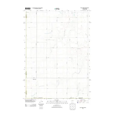
2013 Map of Pilot Grove
USGS Topo · Published 2013About this map
Pilot Grove anchors this rural landscape along the border of Faribault and Martin counties, where the headwaters of the W Br Blue Earth River begin to take shape. The terrain is defined by an extensive network of managed waterways, including Judicial Ditch Number Nineteen and Judicial Ditch Number Seven, which transformed this corner of southern Minnesota into productive farmland. These ditches intersect with natural watercourses like Badger Cr and Little Badger Cr, illustrating the long-term engineering required to drain the regional prairie. Small-scale historical markers, such as the Pilot Grove Cem located along 60th St, offer touchstones for genealogists researching the families that established these agricultural townships. The grid of section roads, from 310th Ave to 370th Ave, remains the primary structure of the county, connecting isolated farmsteads to the settlement at Pilot Grove.
Find a feature on this map
35 named features on this map. Tap any name to fly to it.
Don’t see what you’re looking for? This feature index may not catch every label — zoom into the map to look around manually.
Map Details
Editions of this 2013 Pilot Grove Map
This is the sole edition of this map. No revisions or reprints were ever made.
Other maps of this area

1954 · Fairmont
USGS Topo · 1:250,000

1958 · Fairmont
USGS Topo · 1:250,000

1967 · Pilot Grove
USGS Topo · 1:24,000

1967 · East Chain
USGS Topo · 1:24,000

1967 · Elmore
USGS Topo · 1:24,000

1967 · Granada
USGS Topo · 1:24,000

1967 · Huntley
USGS Topo · 1:24,000
1967 · Blue Earth
USGS Topo · 1:24,000

1972 · Ledyard
USGS Topo · 1:24,000
1972 · Lakota
USGS Topo · 1:24,000