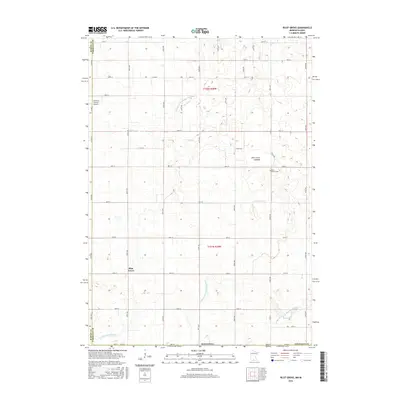
2016 Map of Pilot Grove
USGS Topo · Published 2016About this map
Pilot Grove sits at the heart of this Faribault County landscape, a small settlement defined by a grid of rural routes like Co Rd 101 and 320th Ave. The surrounding terrain is a study in agricultural transformation, where the natural hydrology of the W Br Blue Earth River and Badger Cr is supplemented by an extensive network of man-made waterways, including Judicial Ditch Number Seven and Judicial Ditch Number Nineteen. This systematic drainage of the prairie is most evident at the Pilot Grove Lakebed, a feature that speaks to the historical alteration of the Minnesota wetlands for farming. Near the western border, the small Cornfield Canyon Airport provides a localized landmark amidst the fields. Genealogists will find the Pilot Grove Cem located north of the primary settlement, serving as a primary point of interest for tracing local family roots in this corner of the state near the Martin County line.
Find a feature on this map
46 named features on this map. Tap any name to fly to it.
Don’t see what you’re looking for? This feature index may not catch every label — zoom into the map to look around manually.
Map Details
Editions of this 2016 Pilot Grove Map
This is the sole edition of this map. No revisions or reprints were ever made.
Other maps of this area

1954 · Fairmont
USGS Topo · 1:250,000

1958 · Fairmont
USGS Topo · 1:250,000

1967 · Pilot Grove
USGS Topo · 1:24,000

1967 · East Chain
USGS Topo · 1:24,000

1967 · Elmore
USGS Topo · 1:24,000

1967 · Granada
USGS Topo · 1:24,000

1967 · Huntley
USGS Topo · 1:24,000
1967 · Blue Earth
USGS Topo · 1:24,000

1972 · Ledyard
USGS Topo · 1:24,000
1972 · Lakota
USGS Topo · 1:24,000