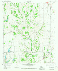
1964 Map of Pilot Grove
USGS Topo · Published 1967About this map
The agrarian landscape of North Texas is captured here in the mid-1960s, centered on the convergence of the West Fork Pilot Grove Creek and East Fork Pilot Grove Creek. This period reveals a rural community defined by small settlements like Pilot Grove and Cannon, where the presence of numerous Gravel Pits indicates the local extraction industry. Genealogists will find significant detail in the distribution of family-named burial grounds and houses of worship, including Worden Cem, Luper Cem, and Binion Cem. The eastern portion of the sheet is marked by the transit corridor of the Missouri Kansas Texas railroad, which skirts the boundary where Grayson, Fannin, and Collin counties meet. From the crossroads at Sedalia to the scattered rural congregations such as Starks Chapel Ch and Bethel Ch, the map documents the persistent layout of small-town Texas before modern suburban expansion began to reach this corner of the state.
Find a feature on this map
31 named features on this map. Tap any name to fly to it.
Don’t see what you’re looking for? This feature index may not catch every label — zoom into the map to look around manually.
Map Details
Editions of this 1964 Pilot Grove Map
2 editions found
Other maps of this area

1901 · Denison
USGS Topo · 1:125,000

1954 · Sherman
USGS Topo · 1:250,000

1958 · Whitesright
USGS Topo · 1:62,500

1958 · Sherman
USGS Topo · 1:250,000

1958 · Sherman
USGS Topo · 1:62,500

1958 · Howe
USGS Topo · 1:24,000

1960 · Blue Ridge
USGS Topo · 1:24,000

1960 · Pike
USGS Topo · 1:24,000

1961 · Van Alstyne
USGS Topo · 1:24,000
1961 · Anna
USGS Topo · 1:24,000