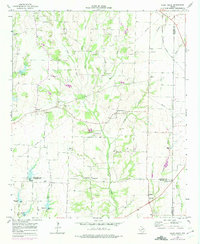
1964 Map of Pilot Grove
USGS Topo · Published 1975About this map
Pilot Grove and the surrounding North Texas countryside are defined by the winding network of Pilot Grove Creek and its tributaries, including the West Fork and East Fork. This 1964 landscape reflects a deeply rooted agricultural and rural community, anchored by numerous country houses of worship such as Starks Chapel, Bethel Ch, and Crossroads Ch. Family histories are preserved in local burial grounds like Luper Cem, Binion Cem, and Worden Cem.
Find a feature on this map
32 named features on this map. Tap any name to fly to it.
Don’t see what you’re looking for? This feature index may not catch every label — zoom into the map to look around manually.
Map Details
Editions of this 1964 Pilot Grove Map
2 editions found
Other maps of this area

1901 · Denison
USGS Topo · 1:125,000

1954 · Sherman
USGS Topo · 1:250,000

1958 · Whitesright
USGS Topo · 1:62,500

1958 · Sherman
USGS Topo · 1:250,000

1958 · Sherman
USGS Topo · 1:62,500

1958 · Howe
USGS Topo · 1:24,000

1960 · Blue Ridge
USGS Topo · 1:24,000

1960 · Pike
USGS Topo · 1:24,000

1961 · Van Alstyne
USGS Topo · 1:24,000
1961 · Anna
USGS Topo · 1:24,000