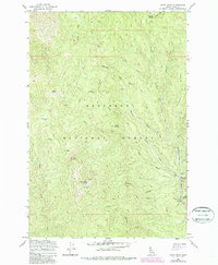
1962 Map of Pilot Knob
USGS Topo · Published 1987About this map
The Nez Perce National Forest defines this high-elevation landscape, where gold mining and forestry shaped the rugged drainages of the Clearwater region. Near the confluence of Newsome Creek and Sing Lee Creek, the Newsome (Site) and its associated Cem reflect the area's early settlement history. Industrial activity is evident through the Pell Placer Mine and extensive Dredge Tailings along the creek beds, while high points like Pilot Knob and Baldy Mtn provided critical vantage points for the Lookout station. Evidence of seasonal habitation and resource management appears at Lytle Camp and the Newsome Work Center, alongside older locations like the Mountain House (Site). The network of drainages, including China Creek, Hayfork Creek, and West Fork Newsome Creek, highlights a terrain defined by narrow valleys and steep ridges such as Radcliff Ridge.
Find a feature on this map
38 named features on this map. Tap any name to fly to it.
Don’t see what you’re looking for? This feature index may not catch every label — zoom into the map to look around manually.
Map Details
Editions of this 1962 Pilot Knob Map
3 editions found

Other maps of this area

1924 · Weippe
USGS Topo · 1:125,000

1931 · Buffalo Hump
USGS Topo · 1:125,000

1934 · Buffalo Hump
USGS Topo · 1:125,000

1956 · Elk City
USGS Topo · 1:250,000

1956 · Hamilton
USGS Topo · 1:250,000

1959 · Hamilton
USGS Topo · 1:250,000

1960 · Elk City
USGS Topo · 1:250,000

1960 · Hamilton
USGS Topo · 1:250,000

1962 · Golden
USGS Topo · 1:24,000

1962 · Center Star Mtn
USGS Topo · 1:24,000