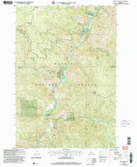
2004 Map of Pilot Peak
USGS Topo · Published 2007About this map
The South Fork Salmon River carves a deep path through this portion of the Payette National Forest, dictating the placement of early infrastructure and small outposts. This 2004 revision, based on surveys dating back to the 1960s, highlights the isolation and utilitarian nature of the landscape at the turn of the 21st century. High-elevation points like China Mountain and Pilot Peak, which features a prominent Lookout, overlook a network of drainages including Elk Creek and Flat Creek. Small centers of activity are sparse, appearing as the settlement of Shiefer and the established Hays Station. The legacy of extraction is visible near the western edge of the map, where the Pony Mine sits at the end of Pony Road. Aviation plays a critical role in accessing this remote terrain, evidenced by multiple clearings designated as Landing Strip along the river banks and creek flats.
Find a feature on this map
43 named features on this map. Tap any name to fly to it.
Don’t see what you’re looking for? This feature index may not catch every label — zoom into the map to look around manually.
Map Details
Editions of this 2004 Pilot Peak Map
This is the sole edition of this map. No revisions or reprints were ever made.
Other maps of this area

1937 · Big Creek
USGS Topo · 1:48,000

1942 · Big Creek
USGS Topo · 1:62,500

1956 · Warren
USGS Topo · 1:62,500

1956 · Elk City
USGS Topo · 1:250,000

1960 · Elk City
USGS Topo · 1:250,000

1969 · Profile Gap
USGS Topo · 1:24,000

1969 · Pony Meadows
USGS Topo · 1:24,000

1969 · Parks Peak
USGS Topo · 1:24,000

1969 · Wolf Fang Peak
USGS Topo · 1:24,000

1969 · Williams Peak
USGS Topo · 1:24,000