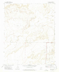
1972 Map of Pilot Rock
USGS Topo · Published 1975About this map
Navajo Indian Reservation lands meet the northern boundary of Petrified Forest National Park in this remote stretch of Navajo County. The landscape is defined by the high point of Pilot Rock and the drainage of Leroux Wash, which snakes through the desert terrain. Significant archaeological and historical interest is noted by several clusters of Ruins found near the Indian Reservation Boundary and within the Petrified Forest Wilderness. These markers indicate a long human presence in an area otherwise characterized by water management features like Rabbit Tank, Little Rabbit Tank, and Two Milk Tank. A network of jeep trails provides the only access through this arid environment, connecting the washes and high plateaus.
Find a feature on this map
12 named features on this map. Tap any name to fly to it.
Don’t see what you’re looking for? This feature index may not catch every label — zoom into the map to look around manually.
Map Details
Editions of this 1972 Pilot Rock Map
This is the sole edition of this map. No revisions or reprints were ever made.
Other maps of this area

1883 · Tusayan
USGS Topo · 1:250,000

1886 · Tusayan
USGS Topo · 1:250,000

1886 · Fort Defiance
USGS Topo · 1:250,000

1892 · Fort Defiance
USGS Topo · 1:250,000

1947 · Flagstaff
USGS Topo · 1:250,000

1954 · Flagstaff
USGS Topo · 1:250,000

1954 · Gallup
USGS Topo · 1:250,000

1958 · Gallup
USGS Topo · 1:250,000

1958 · Flagstaff
USGS Topo · 1:250,000

1959 · Gallup
USGS Topo · 1:250,000