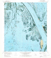
1971 Map of Pilottown
USGS Topo · Published 1974About this map
The Mississippi River splits into its final distributaries at the Head of Passes, a critical maritime junction where pilots navigate the shifting delta. In the early 1970s, Pilottown served as a remote outpost for river pilots, situated along the Raphael Pass and near the Lookout Tower Wildlife Headquarters. This orthophotomap illustrates the fragile transition between land and water, showing the extensive network of natural channels like Main Pass and Southwest Pass alongside human industrial footprints. The West Bay Oil and Gas Field and various oil wells and pipelines reveal the era's intensive resource extraction within the marshlands. Conservation efforts are equally prominent, with the Delta National Wildlife Refuge and the Pass A Loutre State Waterfowl Management Area protecting the vast reaches of Zinzin Bay and family-named landmarks like Bob Taylors Pond and Mary Bowers Pond.
Find a feature on this map
46 named features on this map. Tap any name to fly to it.
Don’t see what you’re looking for? This feature index may not catch every label — zoom into the map to look around manually.
Map Details
Editions of this 1971 Pilottown Map
2 editions found
Other maps of this area

1893 · East Delta
USGS Topo · 1:62,500

1893 · Forts
USGS Topo · 1:62,500

1893 · West Delta
USGS Topo · 1:62,500

1935 · South Pass
USGS Topo · 1:31,680

1946 · Pass Du Bois
USGS Topo · 1:31,680

1946 · Pass Tante Phine
USGS Topo · 1:31,680

1947 · Pass A Loutre West
USGS Topo · 1:31,680

1947 · Venice
USGS Topo · 1:31,680

1947 · Fort St. Philip
USGS Topo · 1:31,680

1947 · Southwest Pass
USGS Topo · 1:31,680