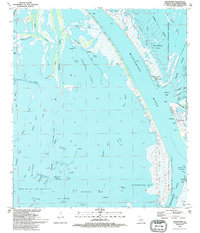
1993 Map of Pilottown
USGS Topo · Published 1994About this map
Pilottown stands as a vital outpost for river pilots navigating the final reaches of the Mississippi Delta, positioned where the Mississippi River splits into its major distributaries. This maritime community is situated at the Head of Passes, a critical junction for international shipping. The surrounding landscape is a complex network of marshes and waterways including Jaquines Island and Red Pass. The presence of the West Bay Oil and Gas Field with its numerous platforms and pipelines highlights the region's industrial importance, while the Delta National Wildlife Refuge and Pass a Loutre State Wildlife Management Area preserve the natural habitat. Small water bodies like Mary Bowers Pond and Locust Pond are scattered throughout the wetlands, alongside specific landmarks such as the Lookout Tower Wildlife Headquarters.
Find a feature on this map
51 named features on this map. Tap any name to fly to it.
Don’t see what you’re looking for? This feature index may not catch every label — zoom into the map to look around manually.
Map Details
Editions of this 1993 Pilottown Map
2 editions found
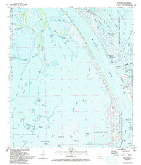
Other maps of this area

1893 · East Delta
USGS Topo · 1:62,500

1893 · Forts
USGS Topo · 1:62,500

1893 · West Delta
USGS Topo · 1:62,500

1935 · South Pass
USGS Topo · 1:31,680

1946 · Pass Du Bois
USGS Topo · 1:31,680

1946 · Pass Tante Phine
USGS Topo · 1:31,680

1947 · Pass A Loutre West
USGS Topo · 1:31,680

1947 · Venice
USGS Topo · 1:31,680

1947 · Fort St. Philip
USGS Topo · 1:31,680

1947 · Southwest Pass
USGS Topo · 1:31,680