
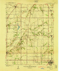
1940 Map of Pimento
USGS Topo · Published 1940About this map
Prairieton and the surrounding farm country of Vigo County are documented here just before the mid-century, showing a landscape defined by its prairie origins and early transit routes. The Harrison Trail cuts through the western sections, while the Chicago and Eastern Illinois railroad serves as the industrial spine for eastern settlements like Pimento and Farmersburg. This era reveals a network of rural social centers, including Farmers Chapel, Oregon Ch, and Friendship Ch, which anchored the local agricultural community.
Find a feature on this map
30 named features on this map. Tap any name to fly to it.
Don’t see what you’re looking for? This feature index may not catch every label — zoom into the map to look around manually.
Map Details
Editions of this 1940 Pimento Map
2 editions found
Other maps of this area

1932 · Marshall
USGS Topo · 1:62,500

1937 · Marshall
USGS Topo · 1:62,500

1940 · Lewis
USGS Topo · 1:24,000

1941 · Seelyville
USGS Topo · 1:24,000

1941 · Terre Haute
USGS Topo · 1:24,000

1942 · Fairbanks
USGS Topo · 1:24,000

1942 · Shelburn
USGS Topo · 1:24,000

1942 · Hutton
USGS Topo · 1:24,000

1942 · Dennison
USGS Topo · 1:24,000

1943 · Hymera
USGS Topo · 1:24,000