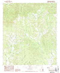
1988 Map of Pinckneyville
USGS Topo · Published 1988About this map
Pinckneyville serves as the focal point of this southwestern Mississippi landscape, situated in a region defined by a dense network of winding waterways and family-named landmarks. The topography is marked by significant drainage systems, including the complex course of Pinckneyville Bayou and Sara Bayou, which weave through the southern portion of the quadrangle. Small rural settlements like Hooks and Donegal are tucked away near the state's edge, connected by a web of unimproved roads and trails that traverse the hilly terrain.
Find a feature on this map
28 named features on this map. Tap any name to fly to it.
Don’t see what you’re looking for? This feature index may not catch every label — zoom into the map to look around manually.
Map Details
Editions of this 1988 Pinckneyville Map
This is the sole edition of this map. No revisions or reprints were ever made.
Other maps of this area

1906 · Bayou Sara
USGS Topo · 1:125,000

1936 · Woodville
USGS Topo · 1:62,500

1939 · St. Francisville
USGS Topo · 1:62,500

1939 · Artonish
USGS Topo · 1:62,500

1941 · Batchelor
USGS Topo · 1:62,500

1953 · Natchez
USGS Topo · 1:250,000

1954 · Artonish
USGS Topo · 1:62,500

1954 · Baton Rouge
USGS Topo · 1:250,000

1955 · Artonish
USGS Topo · 1:62,500

1955 · Batchelor
USGS Topo · 1:62,500