
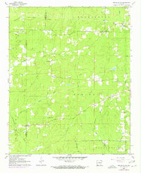
1962 Map of Pine Bluff NW
USGS Topo · Published 1963About this map
Bayou Bartholomew snakes through the northeastern corner of this landscape, marking a distinct transition in the drainage patterns of Jefferson County. The area is defined by a dense network of small rural congregations and family burial grounds, such as Hautt Cem and Barnes Chapel, which anchor the small settlements of Washington and Darysaw. The interior is heavily wooded and crisscrossed by numerous waterways including Johnson Creek and Derrieusseaux Creek, reflecting a mid-century topography still largely shaped by natural timber and small-scale agriculture rather than urban expansion. Clearings for Gravel Pits and the presence of a Lookout Tower suggest a local economy tied to the land's raw resources. The placement of the Grant Co Jefferson Co line through these woods highlights the remote character of the borderlands during the early 1960s.
Find a feature on this map
35 named features on this map. Tap any name to fly to it.
Don’t see what you’re looking for? This feature index may not catch every label — zoom into the map to look around manually.
Map Details
Editions of this 1962 Pine Bluff NW Map
4 editions found
Other maps of this area

1932 · Pastoria
USGS Topo · 1:62,500

1935 · Pastoria
USGS Topo · 1:62,500

1955 · Little Rock
USGS Topo · 1:250,000

1956 · Little Rock
USGS Topo · 1:250,000

1960 · Little Rock
USGS Topo · 1:250,000

1962 · Pine Bluff
USGS Topo · 1:24,000

1962 · Faith
USGS Topo · 1:24,000

1962 · Kedron
USGS Topo · 1:24,000

1964 · Little Rock
USGS Topo · 1:250,000

1964 · Staves
USGS Topo · 1:24,000