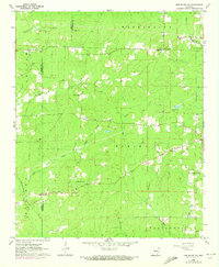
1962 Map of Pine Bluff NW
USGS Topo · Published 1973About this map
Bayou Bartholomew meanders through the eastern edge of this landscape, marking the boundary between the cultivated lowlands and the timbered uplands of Washington and Spring townships. Recorded in 1962, the map documents a rural community defined by a high density of small-scale country churches and family cemeteries, suggesting a legacy of close-knit settlement. From Barnes Chapel in the north to Double Wells Ch in the southwest, these landmarks anchor the landscape alongside a network of creeks like Pumpkinvine Creek and Johnson Creek. This edition includes 1971 revisions, most notably detailing a series of fence and field lines that trace the mid-century agricultural footprint across the Grant and Jefferson County line. The presence of Camp Ta-Lo-Hi and a Lookout Tower indicates the area's transition toward recreational and forestry management during this period.
Find a feature on this map
34 named features on this map. Tap any name to fly to it.
Don’t see what you’re looking for? This feature index may not catch every label — zoom into the map to look around manually.
Map Details
Editions of this 1962 Pine Bluff NW Map
4 editions found
Other maps of this area

1932 · Pastoria
USGS Topo · 1:62,500

1935 · Pastoria
USGS Topo · 1:62,500

1955 · Little Rock
USGS Topo · 1:250,000

1956 · Little Rock
USGS Topo · 1:250,000

1960 · Little Rock
USGS Topo · 1:250,000

1962 · Pine Bluff
USGS Topo · 1:24,000

1962 · Faith
USGS Topo · 1:24,000

1962 · Pine Bluff NW
USGS Topo · 1:24,000

1962 · Kedron
USGS Topo · 1:24,000

1964 · Little Rock
USGS Topo · 1:250,000