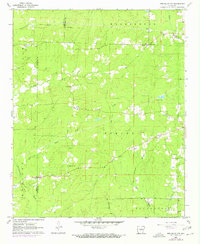
1962 Map of Pine Bluff NW
USGS Topo · Published 1972About this map
The boundary between Grant Co and Jefferson Co cuts through a landscape defined by small rural congregations and family cemeteries in the early 1960s. The area is heavily intersected by seasonal watercourses such as Pumpkinvine Creek, Johnson Creek, and Derrousseaux Creek, which drain toward the prominent Bayou Bartholomew in the northeast. This topographical study illustrates a transition from timberland and open fields to established rural community centers, evidenced by the cluster of social hubs like Barnes Sch and Barnes Chapel.
Find a feature on this map
34 named features on this map. Tap any name to fly to it.
Don’t see what you’re looking for? This feature index may not catch every label — zoom into the map to look around manually.
Map Details
Editions of this 1962 Pine Bluff NW Map
4 editions found
Other maps of this area

1932 · Pastoria
USGS Topo · 1:62,500

1935 · Pastoria
USGS Topo · 1:62,500

1955 · Little Rock
USGS Topo · 1:250,000

1956 · Little Rock
USGS Topo · 1:250,000

1960 · Little Rock
USGS Topo · 1:250,000

1962 · Pine Bluff
USGS Topo · 1:24,000

1962 · Faith
USGS Topo · 1:24,000

1962 · Pine Bluff NW
USGS Topo · 1:24,000

1962 · Kedron
USGS Topo · 1:24,000

1964 · Little Rock
USGS Topo · 1:250,000