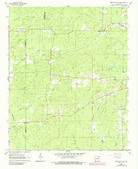
1962 Map of Pine Bluff NW
USGS Topo · Published 1984About this map
Bayou Bartholomew and its winding tributaries define the landscape along the Grant and Jefferson County line. This 1962 aerial photogrammetry survey, updated in the early 1980s, reveals a rural network of homesteads and small community centers connected by gravel roads. Several country churches and family burial grounds serve as anchors for local genealogy, including St Luke Ch and the nearby Heutt Cem. The terrain is characterized by a dense creek system including Pumpkinvine Creek, Johnson Creek, and Derrieusseaux Creek, which carved the drainage patterns that dictated early land use. Evidence of the local timber and recreational economy appears through the presence of a Lookout Tower and Camp Ta-Lo-Ha, while scattered Gravel Pits indicate the small-scale extractive industries active in the region during the mid-20th century.
Find a feature on this map
28 named features on this map. Tap any name to fly to it.
Don’t see what you’re looking for? This feature index may not catch every label — zoom into the map to look around manually.
Map Details
Editions of this 1962 Pine Bluff NW Map
4 editions found
Other maps of this area

1932 · Pastoria
USGS Topo · 1:62,500

1935 · Pastoria
USGS Topo · 1:62,500

1955 · Little Rock
USGS Topo · 1:250,000

1956 · Little Rock
USGS Topo · 1:250,000

1960 · Little Rock
USGS Topo · 1:250,000

1962 · Pine Bluff
USGS Topo · 1:24,000

1962 · Faith
USGS Topo · 1:24,000

1962 · Pine Bluff NW
USGS Topo · 1:24,000

1962 · Kedron
USGS Topo · 1:24,000

1964 · Little Rock
USGS Topo · 1:250,000