2023 Map of Pine Bush
USGS Topo · Published 2023About this map
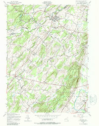
The Wallkill Valley landscape is defined by the winding course of the Shawangunk Kill and the Wallkill River, which frame a region of dense small-hamlet settlement and low-lying wetlands. Long-established communities such as Pine Bush, Bullville, and Montgomery anchor the local geography, connected by a network of rural roads that cross numerous watercourses like the Dwaar Kill and Pakanasink Creek. The map records several notable family and community landmarks, including Howell Cem and Crawford Cem, which offer significant value for genealogists tracing early Orange and Ulster County residents. To the south, the industrial and transport footprint expands near the Orange County Airport and the outskirts of Montgomery, where the terrain flattens toward the river. This survey captures the modern character of these historic Mid-Hudson Valley crossroads, where extensive swamps like Cedar Swamp and Pine Swamp persist alongside suburban expansion and infrastructure.
Find a feature on this map
131 named features on this map. Tap any name to fly to it.
Don’t see what you’re looking for? This feature index may not catch every label — zoom into the map to look around manually.
Map Details
Editions of this 2023 Pine Bush Map
This is the sole edition of this map. No revisions or reprints were ever made.