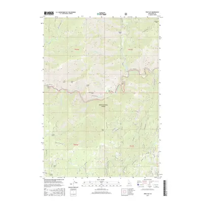
2017 Map of Pine Flat
USGS Topo · Published 2017About this map
The South Fork Payette River carves a dramatic path through this section of the Boise National Forest, serving as a central artery for both the landscape and local recreation. Near the river's bend, Pine Flat Hot Springs stands as a notable landmark alongside the small settlements of Pine Flat and Birch Flat. The Banks-Lowman Hwy follows the river's course, providing the primary access through this mountainous terrain where the Deadwood River merges into the main flow at Oxbow Bend.
Find a feature on this map
66 named features on this map. Tap any name to fly to it.
Don’t see what you’re looking for? This feature index may not catch every label — zoom into the map to look around manually.
Map Details
Editions of this 2017 Pine Flat Map
This is the sole edition of this map. No revisions or reprints were ever made.
Other maps of this area

1894 · Idaho Basin
USGS Topo · 1:125,000

1909 · Garden Valley
USGS Topo · 1:125,000

1955 · Hailey
USGS Topo · 1:250,000

1957 · Pioneerville
USGS Topo · 1:24,000

1957 · Challis
USGS Topo · 1:250,000

1959 · Hailey
USGS Topo · 1:250,000

1959 · Garden Valley
USGS Topo · 1:62,500

1960 · Challis
USGS Topo · 1:250,000

1962 · Hailey
USGS Topo · 1:250,000

1963 · Challis
USGS Topo · 1:250,000